General Information
Nahiya (Subdistrict)
Şera
Also Known As
Al-Daha, Matinli, Metîna, Şeranê, الضحى, ماتنلي
Tribes
Caferî, Cafirî, Koçer, Metîna, Metînan, Milan, Ne'imî, Neîmî, Reşî, Sorikî, Sûrkî, Şikakî, Şêran
Families, Clans, etc.
Cebûlo, Cebûlî, Ebbî, Ebû Alo, Ebû Elo, Elî Axa, Elî Cebûr, Elî Pîro, Hec Ebdo, Hec Nebo, Hecî Biş, Kekeca, Kekeja, Kerbelaş, Kerbelêk, Kurik, Kûrik, Malê Nebê, Malê Selmo, Mestê, Nebê, Nebê Reşê, Pîşê, Qurtal, Qurtalê, Raşê, Reşê, Reşîd, Selmo, Sûkê

Photos
Basic Information about Metîna
Source: Ax û Welat
Etymology: Named after the Metîna tribe or the first settler Metînî
Foundation Date/Period: 300 years ago (estimated as six generations)
Hills: Qeracê Selma, Gabelaka
Shrines: Goristana Şehîd Refîq, Ziyaretgeha Şêx Ûsib, Ziyaretgeha Menên, Ziyaretgeha Henên
Ruins: Mehsere
Wells: Sarnîca Hec Nebo, Sarnîca Mala Selmo, Sarnîca Mala Sûkê, Sarnîca Mala Ebû 'Alo, Sarnîca Mala Hecî Biş, Sarnîca Elî Cebûr
Other Landmarks: Deşta Avgîrê, Xirabê Şera
Source: Khalil Sino
Etymology: Named after Çiyayê Metîna (Mount Metina) in Kurdistan
Foundation Date/Period: Approximately 225 to 250 years ago
Summaries
I. Summary from TirejAfrin Site (English) of Metîna
Source: https://www.tirejafrin.com/site/kura%20afrin%20%20sheran%20-%20Met%C3%AEna.htm
It is stated in the book جبل الكرد (عفرين) دراسة جغرافية Çiyayê Kurmênc (Efrîn): A Geographical Study: Metîna, Metînlê, Duha /1962 - 405AH - 3km - 530m/:
Metîna: The name of a mountain and a well known region in Southern Kurdistan. And "Metînan" is one of the Milan Kurdish tribes, /Wesfî Zekerya p. 664/. It is a large village located on the western slope of a limestone plateau.
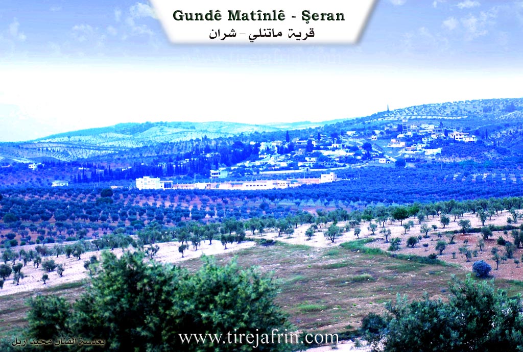
It is stated in the book عفرين .... نهرها وروابيها الخضراء Efrîn... Her River and Her Green Hills: Metînlê: A village located in Çiyayê Kurmênc, belonging to the district of Şera, Efrîn region, Heleb governorate. It is a large village located on a highland and mountainous slope in the northern part of Çiyayê Seman on a limestone plateau. A silt valley passes through it, heading towards Çemê Efrîn (Afrin River). Its soil is clay limestone.
It is bordered to the north by a wide plain planted with olive trees and vines and the village of Xerab Şera, and to the south by a deep valley, a mountain chain, valleys, and the village of Meşelê. To the east, it is bordered by a high mountain chain planted with olive trees, vines, and forest trees, and the village of Qetme. To the west, there is a slope and a fertile agricultural plain, the Riya Bilbil-Meydankê (Bilbil-Meydankê road), and the village of Hulûbiyê Mezin.
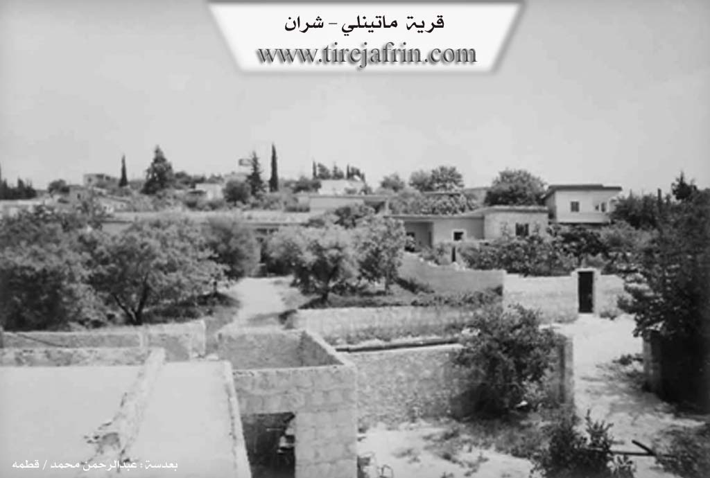
The number of its houses is about 100 houses and its age is about 400 years. Its old houses are made of mud and stone with wooden ceilings, while the modern ones are cement and have spread in the northern and southwestern directions. An electricity network, state drinking water, telephone, a mosque, a primary school, and a paved road connecting to the district and the region are available. It belongs to the Şera municipality. Currently, a massive water tank is being built on the western side of the village to distribute the water of Bendava Meydankê (Meydankê Dam) for drinking to the cities of Efrîn and Ezaz.
The residents of the village work in rain fed agriculture, olives, and grains, as well as irrigated crops from artesian wells (vegetables, pomegranate, apricot, almonds). It is one of the beautiful villages in the Efrîn region. In addition to agriculture, the residents of the village work in raising sheep and goats. Among its most important families is the Elî Axa family. The number of its inhabitants, according to the civil registry on 31/12/2004, is 1934.
Among the holders of higher degrees in the village: Sebrî Hesen bin Husên / Doctorate in Economics Heleb; Menan Silêman Doctorate in Chemistry / France.
Village Mukhtar: Husên Hesen.
Sources of Information:
- Book: جبل الكرد (عفرين) دراسة جغرافية Çiyayê Kurmênc (Efrîn): A Geographical Study by د. محمد عبدو علي Dr. Mihemed Ebdo Elî.
- Book: عفرين .... نهرها وروابيها الخضراء Efrîn... Her River and Her Green Hills by عبدالرحمن محمد Ebdulrehman Mihemed from the village of Qetme.
- Studies of Navenda Tirej Soft / Ebdulrehman Hacî Osman.
- Some residents of the villages.
Preparation and Execution: Manager of Tirej Efrîn site: Ebdulrehman Hacî Osman 20/12/2013
II. Summary of Metîna from Ax û Welat
Source: https://www.youtube.com/watch?v=5LIh3GKG5ns
The village of Metîna, located in the Şera district of Efrîn, holds a history deeply rooted in migration and adaptation to the arid landscape of Çiyayê Kurmênc. According to local elders, the village was founded approximately 300 years ago, a timeline estimated as "six fathers" or generations back. The village derives its name from the Metîna tribe, specifically a first settler named Metînî. However, speakers note that no actual members of the Metîna tribe currently reside there; the name remains a legacy of that initial founding figure who migrated from Bakur (North Kurdistan), potentially linked to Çiyayê Metîn and the village of Şeş.
Originally, the settlement was located in a low-lying plain known as Deşta Avgîrê (The Plain of the Water-Holder/Swamp), near Xirabê Şera. Due to the damp conditions, the ancestors moved the village to its current, higher location. The population is a mosaic of different tribes that arrived over the centuries. The Reşî tribe, including the prominent Mala Selmo (the first family to build houses in the new location), migrated from Çiyayê Reş near Nizib and Entab. Other inhabitants include the Sorikî from Celemê, the Neîmî (who are of Arab origin) from Şwarxanê, and the Caferî tribe, specifically the Mala Cebûlî, who originated from Sînkan or Şingal. The Mala Mestê family represents the Koçer (nomadic) segment, while the Mala Elî Pîro family has lost the knowledge of their specific tribal origins.
Water scarcity defined the village's early history. Lacking natural springs, the villagers were forced to fetch water from Meşalê or Deşta Avgîrê. To survive, the community collectively hand-dug extensive cisterns, known as sarnîc, over 120 years ago. Notable cisterns include those of Hec Nebo, Mala Selmo, and Mala Ebû 'Alo. These structures captured rainwater channeled through trenches dug from the surrounding hills.
The village is surrounded by significant religious and historical landmarks. To the west lies Goristana Şehîd Refîq, a martyrs' cemetery established in 2011 on the site of an older shrine, Ziyaretgeha Şêx Ûsib. To the south is Ziyaretgeha Henên, a major site containing the tombs of notable Kurdish figures such as Nûrî Dêrsimî and Cemîl Horo. The village also contains ancient ruins, including traces of four mehsere (olive presses) and numerous caves (şikeft or ziving) that were once attached to every household. Today, one such cave is used by the artisan Ebû Elî (born Îbrahîm Xelîl Mihemed), who carves stone tools and creates art. While the primary economy relies on Zeytûn (olive) cultivation, the village is also known for a high concentration of mechanics and lathe operators.
II. Summary of Metîna from Ax û Welat 2
Source: https://www.youtube.com/watch?v=5iJilStcO2Y
The village of Metîna, located in the Şera district of Efrîn, holds a history deeply rooted in migration and adaptation. According to local oral history, the village was founded approximately 300 years ago, estimated by elders as "six fathers" (generations) back. Its name is derived from the Metîna tribe, specifically an individual named Metînî who was the first to settle there. The tribe originates from Çiyayê Metîn in Bakurê Kurdistanê, a mountain described as having grey soil and a cold water source named Lîlav. Although the original Metînî settlers eventually moved on or vanished, the name remained. The village was initially located in the Deşta Avgîrê, a low-lying, swampy plain, before residents moved to the current elevated location to escape the standing water.
The social fabric of Metîna is diverse, composed of various tribes and families who arrived from different regions. The first family to settle after the founder was Nebê Reşê. A significant portion of the population belongs to the Reşî tribe, including the prominent Selmo and Kekeca families, who migrated from Çiyayê Reş near Nizib and Entab. Other inhabitants include the Ne'imî (specifically the Ebû Elo family of Arab origin), the Cafirî (such as the Cebûlî family from Sînka), as well as members of the Şikakî, Sûrkî, Şêran, and Koçer tribes. The Mestê family is identified as Koçer. Some families, like Sûkê, moved to Metîna from nearby Qestelê.
Geographically, Metîna is surrounded by significant religious and historical landmarks. To the east lies Qeraca and Ziyaretgeha Menên; to the south is the village of Meşalê and Ziyaretgeha Henên; and to the west is Ziyaretgeha Şêx Ûsib, which has been converted into a cemetery for martyrs known as Goristana Şehîd Refîq. Ziyaretgeha Henên is particularly notable as an ancient site containing the graves of Kurdish intellectuals Nûrî Dêrsimî and Cemîl Horo, and is traditionally associated with Henanê, believed to be a brother of the prophet Dawûd, with traces of Jewish history symbolized by triangular tree formations.
Historically, water scarcity was a major challenge for Metîna. Residents relied on rainwater harvesting through hand-dug cisterns known as Sarnînc. Notable cisterns include those dug by Hec Nebo and Hec Elî Cebûrî. Before modern plumbing, villagers had to fetch water from Meşalê or rely on the Deşta Avgîrê. The village is also known for its olive groves, which remain the primary agricultural staple. A unique resident featured in the documentary is Ibrahîm Xelîl Mihemed, known as Ebû Elî, a craftsman who lives and works in a cave (Şikeft), creating tools and "antiques" by hand without modern machinery, embodying the village's tradition of self-reliance.
II. Summary of Metîna from Khalil Sino
Source: https://www.youtube.com/watch?v=YRqH8EXrVgc
The village of Metîna is located in the Efrîn region. According to the village Mukhtar, Mihemed Mihemed (known as Bavê Azad), the settlement owes its name to Çiyayê Metîna (Mount Metina) in Kurdistan. The village was founded approximately 225 to 250 years ago. Before the village was established, the area was an uninhabited wilderness.
The history of Metîna begins with settlers who did not initially construct houses. The first arrivals, belonging to Malê Selmo, lived in a cave (şikeft) located below the current village site, near the road to the city. They were later joined in this cave by Malê Nebê, the family of the current Mukhtar. Eventually, the settlers moved out of the cave to build the village proper. Two brothers, Selmo and 'Emo, along with Malê Nebê, constructed three houses arranged in a triangle (mûseles) or "three-cornered" layout. They enclosed this area with a single courtyard (hewş) to protect their livestock. Over time, the village population grew with the arrival of people from other locations, such as Sînka.
The agricultural landscape of Metîna has shifted significantly over time. Historically, the villagers cultivated grains and legumes, including wheat (genim), lentils (nîsk), chickpeas (nok), and vetch (julban). Today, the land is almost entirely dominated by olive trees (zeytûn). Recently, farmers have begun diversifying with cash crops such as coriander (kizber), cumin (kemûn), nigella (reşreşk), and safflower ('esfir). The village relies on groundwater, possessing approximately 40 private wells inside homes and about 10 communal wells. There is an old mosque in the village, which Bavê Azad notes has stood for about 75 years.
The social life of Metîna is depicted through the experiences of its elders. Bavê Hesen (Nûrî Hesen), a contemporary of the Mukhtar, reflects on the past, noting that while life was physically harder (cefo) in the old days, there was a stronger sense of respect and understanding among people compared to the present. The documentary also features Yûsiv Hec Ebdo (known as Ebû Firas) and his wife Feyroz. While Feyroz is originally from Efrîn city, Ebû Firas is a native of Metîna who spent decades living and working in Latqiyê and Heleb. They returned to the village due to the war in Syria. Their story highlights the dispersion of families, as they send greetings to their children living abroad in the United States.
II. Summary of Metîna from Afrin 366
Source: https://www.youtube.com/watch?v=XbBQaRu72J8
The documentary explores the village of Mêtîna in the Efrîn region. The hosts begin their journey at the bridge below Meydankê, observing the heavy water flow and fish before heading into the village to visit residents.
An elder explains the origins of Mêtîna. He notes that the village was founded roughly 250 to 300 years ago when the Selmo family first arrived and settled in the area. Before they built houses, the early inhabitants lived in the ancient caves that dot the landscape. The elder explains that the area was originally a wilderness but was chosen for its excellent summer pastures. The village was named after Mêtîna, another village in Kurdistan. People used to say to bring their guests to the people of Mêtîna because it was lush, green, and beautiful like a paradise.
Today, the village consists of about 120 to 130 houses. The community is made up of several prominent families, including the Ebû Elo, Raşê, Cebûlo, Kurik, Hec Ebdo, Kerbelêk, and Reşîd families. Many residents have migrated abroad to countries like Tirkiye, Elmanya, and Emerîka, leaving some homes empty.
The village is notable for its historic caves. The elder explains that almost every house has a cave underneath or nearby. These caves date back to ancient times, with the elder attributing their original excavation to the Fîniqiyîn. Over the centuries, villagers used these carved spaces to shelter livestock like cattle, mules, and sheep, or to store firewood for the winter. The village architecture is characterized by beautiful stone courtyards and lush greenery.
Mêtîna offers sweeping views of the surrounding geography. From the village, one can see the mountains of Çiyayê Bilbilê, the snow capped peaks of Çiyayê Kawir, Çiyayê Hawarê, and even the distant Toros and Hemanos ranges. Other nearby landmarks mentioned include the ruins of Xirabê Şaro and neighboring villages like Şorbe, Gobelek, Şera, and Etr. A traditional song played during the documentary also references regional landmarks such as Çemê Meydankê, Gola Meydankê, Çemê Gemrokê, and Çiyayê Lêlûnê.
The documentary captures the resilient and hospitable spirit of the villagers. Residents are proud of their clean and secure environment, noting improvements in local infrastructure like electricity and water. They send warm greetings to their relatives abroad, to the Kurmanc people, and across all four parts of Kurdistan, hoping for future reunions in their beautiful village.
II. Ax û Walat Book 1
187
THE VILLAGE OF METÎNA
Friday 23. 12. 2016
The village of Metîna is affiliated with the Şera district of the Efrînê canton, located 2 km from the town of Şera and 15 km northeast of the city of Efrînê.
The first person to settle in the village of Metîna was known by the name ((Metînî)), and he himself was one of the Metîna tribe, but no one remained after him, meaning he did not continue in the village. Therefore, the name Metîna was given to the village.
The village was previously on the ((Avgîrê)) plain, which is to the west of the village of Xirabê Şera. The family of Nebê Reşê was the first
188
family to settle in the village after Metînî. The people who settled in the village were from many tribes, among them: the Sorkî tribe from Celemê, the Reşî from the Reşa mountain, the Ni’êmî who are originally Arabs from Şiwarxe, and the Cafirî from Sînka.
Initially, 3 families built houses in the village, they are: the family of Selmo, Kurik, and Nebê.
To the east of the village are Selma's garage, the village of Qitmê, and the Menên shrine; to the south are the village of Meşalê and the Henên shrine; to the west is the Şêx Ûsib shrine, which has now become the martyrs' cemetery named Goristana Şehîd Refîq; to the north are the villages of Xirabê Şera, Gabeleka, and the Avgîrê plain.
The Henên Shrine: it is a large and ancient cemetery. The graves of many famous people are there, such as Nûrî Dêrsimî, Cemîl Horo, ... Its name comes from ((Henano)), which is mentioned in the holy book of the Torah, where Henano was the brother of the prophet David. Therefore, the six-pointed star, which is a symbol of the Jews, appeared on some graves.
The Cemetery of Ş. Refîq: it used to be a shrine, but in 2011 it became the martyrs' cemetery named Ş. Refîq, and to this day, more than (1500) martyrs from Kurds and Arabs who gave their lives in the war and resistance in Rojava and Syria have been buried there.
189
The people of the village make their living from agriculture, primarily from the cultivation of olive groves. Some people also work in various factories in the town of Şera and the city of Efrînê. About 25 people work as employees in the institutions and bodies of the Democratic Autonomous Administration.
DRINKING WATER STATION: it has been operating since 2008 for the purification and distribution of drinking water to the cities of Efrîn and Ezazê and the surrounding villages, and about 10 people from the village of Metîna work there. Twice a week, it sends drinking water to the residents.
More than 150 houses and nearly 2000 people live in the village of Metîna, but now many people have migrated.
There are 12 families in the village:
The family of Nebê, Reşê, Kurik, Cebûlî, Hemê, Korlemê, Selmo, Kerbelaş, Ebû Elo, Hec Ebdo, Elî Pîro, and the family of Şêx Hem.
There are 6 martyrs from the village:
Martyr Çîlo, Hisên, Henan, Serbest, Şiyar, and Ş. Azad.
There is a primary school for educating the village children and a mosque in the village. The village commune is named Ş. Serbest, and the village school is also named Ş. Serbest.
190
Reşîdê Hec Nebo is one of the revolutionaries who, along with Mistefa Çolaq and Ehmedê Rûtê, carried out many activities and battles against the French. He was martyred in an activity, and his body was buried at the Henên shrine.
Transcriptions and Subtitles
| Source | Video | Subtitles | Transcript |
|---|---|---|---|
| Afrin 366 1 | Watch Video | Download SRT | View Transcript |
| Ax û Welat 1 | Watch Video | Download SRT | View Transcript |
| Ax û Welat 2 | Watch Video | Download SRT | View Transcript |
| Khalil Sino 1 | Watch Video | Download SRT | View Transcript |
Foundation/Origin Information of Metîna
Among its most important families is the Ali Agha family.
Source: TirejAfrin Site
First settled by three families—Selmo, Korik, and Nebênê—in a lower, swampy plain before being moved to its current location.
Source: Ax û Walat Transcript
Established on land that was formerly just tents and ruins. Founded by the Malê Selmo and Malê Nebê families, led by the brothers Selmo and Umo, who purchased the land from the people of Sharran village. The community later grew with the arrival of the Jolian family, whose ancestor, a Pasha, fled a conflict with the Ottoman Empire from the Jolia region.
Source: Halil Sino Transcript
Possible Village Name Meaning of Metîna
Metina is the name of a mountain and known region in southern Kurdistan. "Metinan" is one of the Kurdish tribal clans.
Source: TirejAfrin Site
Its name originating from the nomadic Kurdish Metîna tribe from Northern Kurdistan.
Source: Ax û Walat Transcript
Named after the Matina plain in Kurdistan.
Source: Halil Sino Transcript
V. Links
- Tirej Afrin:
https://www.tirejafrin.com/site/kura%20afrin%20%20sheran%20-%20Met%C3%AEna.htm - Ax û Welat:
https://www.youtube.com/watch?v=5LIh3GKG5ns - Jawlat:
https://www.youtube.com/watch?v=AUXi5eVJurM - Drone:
https://www.youtube.com/watch?v=h-0UYPGYaLM - Video:
https://www.youtube.com/watch?v=PaKHwFvHFeA - Ax û Welat:
https://www.youtube.com/watch?v=5iJilStcO2Y - Khalil Sino:
https://www.youtube.com/watch?v=YRqH8EXrVgc - Afrin 366:
https://www.youtube.com/watch?v=XbBQaRu72J8