General Information
Nahiya (Subdistrict)
Efrîn
Also Known As
Ma'retê, Maratê, Me'erta, Me'ratê, معراته
Tribes
Berîk, Milî
Families, Clans, etc.
Bettal, Celhût, Cenciya, Cirnasa, Ebdullah Axa, Ehmî Zênê, Hac Izet, Hec Elî, Hecî Nêsir, Henî Emîn, Mala Bêd Xidir, Mala Ebdulrahman Yûsiv, Mala Elî Tijo, Mala Elî Çawîş, Mala Erê, Mala Ewdê Hecî, Mala Eşmomê, Mala Hecî 'Izzet, Mala Henan Elî, Mala Heç Alî, Mala Heç Ezet, Mala Neisê, Mala Ose, Mala Reşo, Mala Xidir, Mala Çawîşler, Mala Şendî, Mala Şêx Zekeriya, Malbata Ehmed Reşo, Malbata Reşîd Rîbî, Malê Henî Elê, Malê Hesen Şindî, Malê Mistefayî Heydû, Malê Mistê Elifê, Malê Nehsê, Malê Resûl, Malê Walî Elqestûn, Malê Çeqelî, Meşayix, Mistê Heydo, Mistî Zikû, Omer Sefûna, Omer Sîvona, Qilîça, Reştî Kolê, Salera, Seydînê Sird, Xelûtlera, Zekeriya, Çawîş, Şindî

Photos
Basic Information about Maratê
Source: Ax û Welat
Etymology: Derived from the Roman era name Miratiyan
Foundation Date/Period: Approximately 915 years ago
Caves: Şikefta Tingê, Şikefta Ereba
Number of Caves: 100
Hills: Çelmêre
Shrines: Xidir Balî
Trees: Darê Gûlberiyê
Source: Khalil Sino
Etymology: Derived from the presence of "du şiket" (two caves) or "du derî" (two openings) at the original site
Number of Caves: 2
Wells: Bîra mala Ehmî Zênê
Summaries
I. Summary from TirejAfrin Site (English) of Maratê
Source: https://www.tirejafrin.com/site/kura%20afrin%20markaz-%20Marate.htm
It is stated in the book جبل الكرد (عفرين) دراسة جغرافية Çiyayê Kurmênc (Efrîn): A Geographical Study by د. محمد عبدو علي Dr. Mihemed Ebdo Elî: Maratê / 4671 inhabitants - 995 houses - 5km - 380m /:
Al-Asadi mentioned, citing Father Armaleh, that the name is of Aramaic origin: "Ma'rasta," meaning the Cave of the Vine.
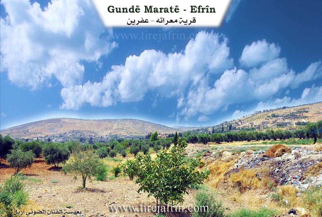
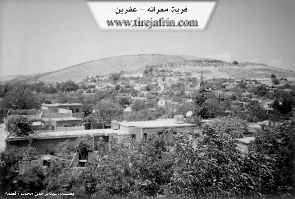
It is a large village located on the lower slope of a mountainous height, surrounded by it from the west, north, and south. Wadi Maratê passes through it from west to east. The village spring is located in its northwestern corner, and its waters are distributed to most of its homes. It is a center for the Omer Sîvona family, which is known in Çiyayê Kurmênc.
It is stated in the book عفرين .... نهرها وروابيها الخضراء Efrîn... Her River and Her Green Hills by the writer عبدالرحمن محمد Ebdulrehman Mihemed from the village of Qetme:
Maratê is a village in Çiyayê Kurmênc, belonging to the villages of the central district and region of Efrîn, Heleb governorate. It is a very large village located on the lower slope of the limestone Mount Hecî. It is penetrated by Wadi Maratê from the northwest to the southeast, which feeds into Wadi Sêl heading east toward the Efrîn river.
It is bordered to the north by a mountainous height planted with olive trees and the village of Xelnêr; to the south by a valley planted with olive and walnut trees and the village of Babîlît; to the east by a wide, agriculturally fertile plain and the city of Efrîn directly; and to the west by a high mountain chain planted with olive trees and vines, Biyûk Edbe, Tel Xazî, and Keferdêlê Jêrîn.
Its lands are mountainous, plain, and agricultural. The number of its houses is approximately 600, and its age is 700 years. Its dwellings are of stone and mud with wooden roofs, though currently, modern cement and stone dwellings have overwhelmed it and started spreading from the eastern side. An electricity network is available, as well as drinking water from the well and the spring located in the village. It contains a primary and preparatory school. A municipality building, a telephone center, and a modern mosque have been established in it. An asphalt road reaches the center of the village and the city of Efrîn.
The residents work in rain-fed agriculture on an area of 965 hectares (grains, legumes, olive trees, walnuts, and pomegranates) and extensively in irrigated agriculture from artesian wells, where they also grow summer vegetables. They also raise sheep and goats. There are three modern olive presses in the village. It is one of the old villages in the region.
Among the holders of higher degrees in the village:
Celal Begdaş / PhD in Archaeology / Germany.
Idrîs Xelîl Mihemed / PhD in Food Industries / Under completion / Germany.
Village Mukhtar: Elî Cawîş Mihemed.
Preparation and Execution:
Manager of Tirej Efrîn site: Ebdulrehman Hacî Osman
20/12/2013
Sources
Book: جبل الكرد (عفرين) دراسة جغرافية Çiyayê Kurmênc (Efrîn): A Geographical Study by د. محمد عبدو علي Dr. Mihemed Ebdo Elî.
Book: عفرين .... نهرها وروابيها الخضراء Efrîn... Her River and Her Green Hills by عبدالرحمن محمد Ebdulrehman Mihemed.
II. Summary of Maratê from Afrin Zeyton
Source: https://www.youtube.com/watch?v=0cTNrtYja4M
The village of Maratê, located approximately 5 kilometers from the city of Afrin, carries a history deeply rooted in antiquity. The name itself is the subject of two prevailing theories: historical texts suggest it derives from a Syriac word meaning "the cave," while local oral tradition attributes it to a Roman ruler named Maratinus who once governed the area. The village's deep historical footprint was previously attested to by an inscribed rock located in Şikefta Ereban (Cave of the Arabs), which dated the settlement to at least 720 years ago, though this artifact has been lost for decades. Elders believe the village is much older, pointing to ancient dwellings and nearby archaeological sites like Qaziqlê and Xilnêr.
Maratê played a significant role in the regional resistance against colonial powers. During the Great Syrian Revolt, the nationalist leader Ibrahim Hananu visited the village to coordinate with the revolutionaries of Afrin. The village is geographically defined by its position on the slopes of two facing mountains and its proximity to Galyê Kûr (The Deep Valley). It was historically renowned for its abundant water sources, specifically Kaniya Mezin (The Big Spring). Elders recall when this spring produced enough water to irrigate the village's once-famous pomegranate orchards and flow all the way to Afrin city. However, over the years, the water levels have drastically diminished, and the agricultural focus has shifted primarily to olive cultivation.
The social fabric of Maratê began with three primary households: Mala Henan Elî, Mala Bêd Xidir, and Mala Erê. Over time, the population expanded, and the village is now home to various lineages, including members of the Berîk tribe. Notable historical residences include the homes of Şêx Zekeriya and Hecî 'Izzet. The village is also culturally distinguished by the Mala Çawîşler family, known for their musical heritage, and the Malbata Reşîd Rîbî, known for traditional dance. Residents like Şiyar Mihemed Şêxo actively preserve this heritage by collecting agricultural tools and household artifacts to ensure the "turas" (heritage) of their ancestors is not lost.
Spiritual and natural landmarks anchor the village's identity. A massive oak tree known as Darê Gelberiyê stands in the village; it is estimated to be centuries old and is so thick that it requires several men to encircle it. The village also contains Ziyareta Xidir Êlyasî, a sacred site associated with Xidir Êlyas. In times of drought, villagers would gather there on Fridays to sacrifice animals and pray for rain, a ritual that elders recall bringing immediate relief from the skies. Historically, the village utilized caves not only for shelter but for industry, with ancient olive presses installed directly inside them.
II. Summary of Maratê from Ax û Welat
Source: https://www.youtube.com/watch?v=TnKcW8LAymA
The village of Maratê, located five kilometers from Efrîn, is a historic settlement with origins tracing back approximately 915 years. According to local oral history and an inscription found in a nearby cave, the village was known in the Roman era as Miratiyan before the name evolved into its current form. The village was founded by seven original households, including Malê Henî Elê, Seydînê Sird, Malê Walî Elqestûn, and Malê Hesen Şindî. These early inhabitants were originally Êzîdî migrants from Şengal who practiced Zoroastrianism before eventually converting to Islam over the centuries. Following the founding families, other lineages such as Cenciya, Qilîça, Cirnasa, and Meşayix arrived, settling in the village where they now live as a cohesive community.
The spiritual life of Maratê centers on the ancient shrine of Xidir Balî, also known as Xizir Îlyas. Although the villagers are now Muslim, they maintain practices tied to this site that date back to their Êzîdî ancestors. Villagers light fires at the site nightly and tie fabrics to a sacred tree to ask Xidir Balî for intercession, particularly for fertility or relief from calamities. In times of drought, the community traditionally gathered there to sacrifice animals and pray for rain.
The landscape around Maratê is defined by its rugged terrain and numerous caves, with elders estimating there are 100 caves in the area. The most famous is Şikefta Tingê, named for the ringing sound (tingînî) that echoes within its 40 meter length. Another significant site is Şikefta Ereba, located near a large spring and an ancient tree known as Darê Gûlberiyê. A historical account provided by Elî Çawîş details how Armenian visitors once identified a stone with Latin inscriptions near this cave which dated the village's founding, though the stone was stolen shortly after its discovery.
Nearby, a mountainous area known as Çelmêre serves as a historical symbol of resistance. The name translates to "Forty Men," referring to a legend of forty warriors who defended the heights. Historically, when the plains of Efrîn were attacked, the villagers would retreat to the rough terrain of Çelmêre for safety. The village is also home to cultural preservationists like Birê Şiyar, who maintains a museum of agricultural tools and antiques to ensure the heritage of the ancestors is not lost, and Ebdulrewûf, a dengbêj who preserves oral history through songs about figures like Şêx Seîd.
II. Summary of Maratê from Khalil Sino
Source: https://www.youtube.com/watch?v=l4a1z6FA5Tw
The village of Maratê, located approximately seven kilometers from the city of Efrîn, traces its origins to a settlement defined by geological features. According to the elder Fewzî Bavê Evdo, the name Maratê is rooted in the existence of "du şiket" (two caves) or "du derî" (two openings) that existed at the village's inception. The history of the settlement is described as ancient, dating back to an era when the community consisted of only four households, with the population split between living in houses and inhabiting the caves. Over generations, Maratê has expanded significantly from these humble beginnings to include over 600 households today.
The social history of Maratê is deeply tied to its water sources and agricultural cooperation. In the past, the community relied on communal springs. A notable historical figure, Mistê Heydo, is remembered for his efforts in clearing a blocked spring, which restored water flow to the village and allowed residents to irrigate their gardens in shifts. However, as noted by residents like Ebdulreûf Çawîş, environmental changes and drought have caused these traditional springs to dry up. The villagers shifted reliance to wells, such as the well of the Ehmî Zênê family (Bîra mala Ehmî Zênê), which served as a crucial water source when others failed. Today, most residents have drilled private wells or rely on water delivery, marking a shift from the communal resource management of the past.
Culturally, the village maintains a connection to its agrarian roots through the memories of its elders. Ehmed Bavê Şiyar, a craftsman and retired driver, preserves the village's heritage by building models of traditional tools that were once essential to daily life, such as the cercer (threshing sled) and dastar (hand mill). Religious life in the village centers around a mosque founded by a teacher named Şêxûs, who established the site to ensure religious education for the community. Despite the village's growth, residents lament the loss of the close-knit social bonds that characterized the era of their ancestors, noting that economic hardship and modernization have altered the traditional lifestyle of Maratê.
II. Summary of Maratê from Multi Channel
The documentary explores the village of Mearatê, located in the western countryside of Efrîn. It is situated on the southern and eastern slopes of the Xazî Kurkî and Xazî Hacî hills, flanked by the surrounding villages of Bablît, Xilênêr, Kefirşîl, and the village known as Gundê Mezin. Positioned on the road connecting Efrîn and Cindirês, Mearatê spans roughly two hundred hectares. Based on the age of its most famous landmark, an ancient oak tree, local residents estimate that the village was founded approximately 350 to 400 years ago. Its municipal council was established in 2001. Over time, many original residents migrated to major cities like Heleb and Şam for public sector jobs, leading to a decline in traditional agriculture. Recently, the village has become a refuge for displaced people from areas like Mearet Hirme in Idlib.
The transcript does not explicitly mention the traditional Kurdish tribes or specific families that originally populated the village. The village is currently home to native Kurdish residents and displaced families from other Syrian provinces. Agriculture remains central, with extensive olive groves, fruit orchards, and livestock rearing consisting of around 1700 sheep and goats. Due to its lush mountainous terrain and abundant springs, beekeeping has recently flourished, particularly among displaced residents like Hesen Mihemed Îd El Ehmed who relocated their hives to the area to produce natural honey.
The most significant natural and spiritual landmark in Mearatê is an ancient oak tree located near the village mosque, which itself is over a century old. As explained by local resident Ehmed Mistefa, this massive tree is estimated to be between 350 and 400 years old and is considered sacred by the villagers. According to local lore, the tree will bleed a fluid resembling blood if anyone attempts to cut its branches, expressing its pain. The tree sits by the main spring and valley that divide the village into northern and southern halves. It serves as a central gathering place for the community during major religious holidays like Cejna Remezanê and Cejna Qurbanê, where villagers set up swings for children and hold communal celebrations. Conversely, the Newroz celebrations take place in a different village square.
Mearatê is characterized by its winding roads, historic stone houses, and deep connection to traditional Kurdish agrarian life. The documentary highlights several notable figures, including Yaşar Mihemed Çeqelî, a local resident who has meticulously collected and preserved Kurdish agricultural heritage. His private museum features traditional basalt grinding stones, wooden mallets known locally as tomaq, vintage lanterns, and equipment used by older generations. Another distinct resident is Mihemed Remzî, a multi talented barber, traditional carpenter, and buzuq player. He inherited his carpentry skills from his father and fashions items like pocket knives and sickles out of apricot wood. He also shares memories of the legendary Kurdish singer Mihemed Elî Tico, noting that he and another local barber, Emîn Ebû Reşîd, shaved the renowned artist for decades free of charge out of deep respect for his art.
II. Summary of Maratê from Multi Channel 2
Me'ratê is an ancient village in the Efrîn region located five kilometers west of the city center. Its name comes from Aramean and Syriac roots translating to Village of Caves, reflecting the ancient dwellings found there. Historically, every older house in the village had its own cave. The village has been inhabited since the Aramean, Syriac, and Roman eras. Over the centuries, migrations and wars caused the population to fluctuate. Around 350 years ago, Kurdish settlers, specifically the Şindî family from the east, arrived and rebuilt the village, joining other Kurdish families who were already present.
During the Great Syrian Revolt against the French, Me'ratê served as a local hub for revolutionary coordination. The prominent leader Ibrahîm Hanano from Kefar Texarîm in Çiyayê Zawiye visited the village to organize with local figures. Additionally, during the late Ottoman era, Mihemed Nûrî Paşa visited the village to rally support for the empire.
The village is home to Kurds and Arab communities, alongside internally displaced persons from areas like Encara, Aleppo, Hama, Raqqa, and Idlib. The Kurdish population originally included Êzîdî residents who later converted and became Muslim. Arab pastoralists initially arrived drawn by the rich grazing lands and abundant water. Notable families include the Şindî, Zekeriya, Hac Izet, and the lineage of Ebdullah Axa.
Physically, the village is divided by a valley with a continuously flowing spring. This water historically provided for drinking, washing, and irrigating crops down to the plains before flowing into the Çemê Efrînê. Nearby stands a massive ancient oak tree estimated to be over 500 years old. Its trunk is so wide that four people cannot fully embrace it. The historical house of Zekeriya and the large multiblock residence of Ebdullah Axa remain as testaments to the traditional architectural heritage of the village, featuring stone seating areas for guards at their entrances.
Me'ratê is celebrated for its lush agricultural landscape, primarily olive groves, and a highly educated population. Residents have a profound affinity for music. The buzuq is widely played, with locals like Ebo Remzî performing Kurdish, Arab, and Turkish melodies, including compositions by the late musician Mihemed Elî Teco. Despite the hardships of war, high fuel costs, and displacement, the village sustains local businesses. For example, Celal Murad operates a sewing workshop employing local workers like Mistefa. The village remains a welcoming refuge where displaced herders, such as Ebdo Omer Cirho, shelter their livestock in the ancient caves of the area. Elders like the imam Ebdilmecîd Hoso and the local historian Şêx Ebdilrehman Hacî proudly preserve the rich historical memories of Me'ratê.
II. Summary of Maratê from Multi Channel 3
The documentary explores the historical village of Maratê located in the Efrîn region. Hosted by Rûliyan Hec Ehmed, the program delves into the deep historical roots and rich cultural heritage of the area. According to village elder Sînor Bekir, Kurdish ancestors settled in the village approximately 400 years ago. However, the region has a much older history involving Aşûrî, Romanî, Horî, and Ermenî populations. The name of the village has several proposed origins. It may derive from the Aşûrî word Moxara, meaning cave, as the village is famous for having over 100 caves. Another legend suggests it is named after an ailing Romanî king named Maryos, who sought healing in the pure air and waters of the settlement. Alternative theories connect the name to the Horî word Mart, meaning holy, or to historical Ermenî residents from 600 to 700 years ago.
When the Kurdish founders first arrived, there were only six or seven households, including Mala Eşmomê, Mala Xidir, Mala Şendî, and Mala Neisê. These early inhabitants lived inside the numerous caves, sharing the space with their livestock. Families like Malê Mistê Elifê and Malê Resûl each had their own designated caves, with the most famous natural shelter being Şkeftê Tîngiyê. Over time, the residents moved out of the caves and constructed homes from stone and mud. The village geography is notably divided by a valley known as Geliyê Heşter. A prominent natural landmark is Darê Gêlberî, an ancient tree over two centuries old. In the past, this massive tree served as a vibrant gathering place where youth would hang swings and celebrate during religious holidays.
Economically, Maratê transitioned from cultivating vineyards and famous pomegranates to relying predominantly on olive orchards. The village preserves its agricultural history through ancient ruins, notably the traditional olive presses called Mekbez. Local expert Xalê Ebdilqahar highlights Mekbaza Rêsul, an ancient press over 150 years old, alongside the ruins of Mekbaza Ebdulrahman Yûsiv and Mekbaza Heç Alî. Additionally, an old traditional watermill run by Elî Maratî showcases how grain was processed for generations.
The village is highly regarded for its dedication to preserving traditional heritage. Residents like Ahmed Ebdulrahman al Bawadkî handcraft wooden agricultural tools from the past, while Şiyar Mihemed Eş Şêx Elî has transformed his home into a museum dedicated to historical artifacts and antique weapons. The social fabric of the village is deeply intertwined with musical traditions. An elderly woman named Zêneb Mihemed recalls the communal joy of musical gatherings. This legacy is detailed by Ebdilraûf Çawîş, a renowned singer born in 1945 from the Mala Elî Çawîş family. He explains that traditional epic songs were historically performed around the local spring Kaniya Fena. He learned his art by listening to older generations from families such as Mala Ewdê Hecî and Malbata Ehmed Reşo, ensuring that the ancient stories of the region continue to echo through time.
II. Summary of Maratê from Khalil Sino 2
Source: https://www.youtube.com/watch?v=8cNey-7jgI8
The documentary explores the village of Maratê, located in the beautiful and
lush region of Efrîn. The host of the program Hatim Ji Efrînê travels to the
village to visit a remarkable local resident named Şiyar. The host had
previously met Şiyar during a local event in the village of Birîmce and was
fascinated by his dedication to preserving local heritage. The episode focuses
entirely on the cultural preservation efforts taking place in Maratê rather
than the ancient history or tribal lineages of the area.
Upon arriving in Maratê, the host praises the natural beauty of the village,
noting its pleasant spring weather, olive trees, and pristine environment. He is
welcomed into the home of Şiyar, who also interacts with someone named Elî.
The courtyard of the home has been transformed into a living museum and is
described by the host as a paradise. Şiyar explains that he has divided his
yard into three distinct sections. The first section is dedicated to his vast
collection of traditional artifacts. The second section houses various animals
and birds, including peacocks, doves, and chickens. The third section is
reserved for agriculture, filled with flowers and local plants.
The core of the documentary revolves around the extensive collection of Kurdish
heritage items that Şiyar has amassed over ten to fifteen years. He estimates
that he has collected thousands of items, with a curated selection of over a
thousand specific historical pieces currently on display. His goal is to protect
the cultural legacy of their ancestors so that future generations will
understand how their forefathers lived and worked. He vividly describes the
difficult yet culturally rich lives of the past, recalling how villagers would
wake up at five in the morning, carry their yokes, and walk into the fields to
harvest the crops.
Among the artifacts displayed are traditional agricultural tools, copper pots,
wooden beds, cradles, and ancient grain grinders known as hand mills. He
demonstrates two different types of hand mills, explaining that one is used
specifically for wheat and another for roasted green wheat. Şiyar also points
out specific vintage items like the Alîman lamp and an old bird cage belonging
to his father. The host and Şiyar, along with individuals mentioned such as
Xelîl and Evdirehman, discuss how these items are frequently brought to
local weddings, regional exhibitions, and cultural events throughout Efrîn.
During the conversation, they discuss a visionary idea inspired by similar
heritage sites in Tirkiye. They propose building a dedicated museum or
constructing a traditional mud brick village in Efrîn where these artifacts
could be permanently exhibited. This would serve as a tourist destination and a
cultural center, ensuring that the agricultural and domestic history of Maratê
and the broader region is never forgotten. The documentary concludes with a
display of traditional Kurdish hospitality inside a customary tent, accompanied
by nostalgic folk music.
II. Summary of Maratê from Khalil Sino 3
Source: https://www.youtube.com/watch?v=m5r_YkHf6gE
The documentary episode is filmed in the village of Maratê in the Efrîn
region, specifically in the courtyard of a local resident named Şiyar, who is
also known as Bavê Ciwan. While the video does not delve into the ancient
history, founding dates, or geographical landmarks of Maratê, it serves as a
cultural archive of the musical heritage and social customs of the area.
The episode introduces Hîm Stêr, a young singer whose real family surname is
Bettal. He hails from the village of Me'mela in the Raco district. The
host and Hîm are joined by local musicians, including the zurna player [Welat
Hec Nasê] from the Hecî Nêsir family, percussionist Elî Çawîş from the
Çawîş family of Maratê, and another musician named Heme. The
videographer Hesen Celhût from the Celhût family is also acknowledged for
his work.
The conversation revolves heavily around the social structure of traditional
wedding celebrations in Efrîn. Hîm Stêr discusses the proper etiquette of
performing, criticizing the modern trend where singers interrupt the music to
give endless spoken greetings to specific guests. He argues that the celebration
belongs exclusively to the bride, the groom, and the hosting family, and that
artists should respect the flow of the event.
A significant portion of the transcript captures traditional oral history
through music. Hîm Stêr performs a long epic song recounting the legends of
historical cavalrymen and warriors. He mentions heroes such as Edlê, [Elîkê
Mistê], Keka Şêx, Bûzan, Silêman, Sedûn, Pêhlewan, Çelo yê Zele,
Mistê Ferhê, Elîyê Zênê, Çerx, and Memê Xemê. The lyrics specifically
highlight Girgirê Milî, pointing to the Milî tribe, and directly reference
the legendary figure Derwêşê Evdî, weaving a rich narrative of bravery,
battles, and tragedy.
The discussion touches upon the modern evolution of local music. Hîm expresses
his deep respect for legendary artists like Mihemedê Elî Tico and [Hesen
Cizrawî], as well as contemporary local singers like Hesen Mihemed and
Mihemed Çawîş. He credits his brother Nêçîrvan and friends like Salah Stêr
and Hemûdê Heleq for supporting his early career. He talks about the
production of his own music, noting collaborations with figures like [Mehdîn
Mihemed], who is known as Mehdînê Me'milo, and Xelîl Xilo. He also shares
the story behind his viral hit Şexsiyye û Wîrose, which unexpectedly gained
massive popularity online after he blended Arabic lyrics with traditional
Kurdish melodies. Additionally, he mentions releasing a patriotic song for
Newroz naming various local areas like Mabeta, Bilbilê, Cindirêsê, Şiyê,
and Şera.
Furthermore, Hîm voices his critical perspective on modern social media
trends. He disapproves of artists performing for virtual gifts on live streams,
feeling it degrades their art. He also addresses the controversial rise of
artificial intelligence in music. He argues that while artificial intelligence
can assist in musical arrangement, it fundamentally lacks the human soul and
cultural authenticity required for true art. The village of Maratê is
showcased here not through ancient ruins, but as a living space for preserving
the rich musical traditions of Çiyayê Kurmênc.
Transcriptions and Subtitles
| Source | Video | Subtitles | Transcript |
|---|---|---|---|
| Afrin Zeyton 1 | Watch Video | Download SRT | View Transcript |
| Ax û Welat 1 | Watch Video | Download SRT | View Transcript |
| Khalil Sino 1 | Watch Video | Download SRT | View Transcript |
| Khalil Sino 2 | Watch Video | Download SRT | View Transcript |
| Khalil Sino 3 | Watch Video | Download SRT | View Transcript |
| Multi Channel 1 | Watch Video | Download SRT | View Transcript |
| Multi Channel 2 | Watch Video | Download SRT | View Transcript |
| Multi Channel 3 | Watch Video | Download SRT | View Transcript |
Foundation/Origin Information of Maratê
It is a center for the family of Omar Safouna.
Source: TirejAfrin Site
First settled by seven Yazidi families who lived within the village's network of roughly 100 caves.
Source: Ax û Walat Transcript
Descends from founding families like Malê Hanan Elî and Malê Beyt Xidir. The village played a significant role in the Great Syrian Revolution, hosting Ibrahim Hanano who came to coordinate with local Afrin rebels.
Source: Afrin Zeyton Transcript
Possible Village Name Meaning of Maratê
From Aramaic: Ma'rasat: the vineyard cave.
Source: TirejAfrin Site
Originally known as Mîrîtiyan because local rulers governed from its network of caves.
Source: Ax û Walat Transcript
Believed to be either Syriac for "The Cave" or derived from the Roman ruler Miritian.
Source: Afrin Zeyton Transcript
V. Links
- Tirej Afrin:
https://www.tirejafrin.com/site/kura%20afrin%20markaz-%20Marate.htm - Ax û Welat:
https://www.youtube.com/watch?v=TnKcW8LAymA - Jawlat:
https://www.youtube.com/watch?v=Aso1PlCPYB4 - Link:
https://www.youtube.com/watch?v=BF-Uxyamr-A - Local FB page:
https://www.facebook.com/gundemarate - Drone video:
https://www.youtube.com/watch?v=DsMBmMRbBsA - Link:
https://www.youtube.com/watch?v=w8nPOg-0EVw - Link:
https://www.youtube.com/watch?v=ZTGPFr3WXcc - Video:
https://www.youtube.com/watch?v=LYNa4o020RI - Link:
https://www.youtube.com/watch?v=Yw4xTc7eZIk - Link:
https://www.youtube.com/watch?v=zQl5BrV-hPA - Link:
https://www.youtube.com/watch?v=wi5kdO0tsCo - Link:
https://www.youtube.com/watch?v=PmHEl1KwLKE - Link:
https://www.youtube.com/watch?v=djObbmK4QCE - Link:
https://www.youtube.com/watch?v=TXQR1PFGnYQ - Link:
https://www.youtube.com/watch?v=bGwKQPsk4W4 - Link:
https://www.youtube.com/watch?v=tQBy3RZtYWc - Link:
https://www.youtube.com/watch?v=T1nE9gaLzdU - Link:
https://www.youtube.com/watch?v=aJPmEhqfkNQ - Khalil Sino:
https://www.youtube.com/watch?v=l4a1z6FA5Tw - Afrin Zeyton:
https://www.youtube.com/watch?v=0cTNrtYja4M - Multi Channel:
https://youtu.be/c3YlEeXgulI?si=IUQh-R2S30Db994V - Khalil Sino:
https://www.youtube.com/watch?v=8cNey-7jgI8 - Khalil Sino:
https://www.youtube.com/watch?v=m5r_YkHf6gE